Author Archives: Mark Halverstadt

Day 30, Mile 454.5 – Bears, Poodle Dog, and The Saufleys

After a wonderful stay in Wrightwood last week, we hiked out on Friday and climbed to the summit of Mt. Baden-Powell, a peak in the San Gabriel Mountains. Named after the founder of the Boy Scouts, it’s a 9,400 ft. mountain and the highest point on the PCT in Southern California. It was a hard hike but very beautiful, with clouds lining the south side of the mountain ridge and a clear view of pines laid out before us to the north. We hiked down the San Gabriel Mountains in the afternoon and camped among some weekenders.

The next day was hot and involved a three-mile detour on the highway to avoid an endangered species habitat (that of the Mountain Yellow-legged Frog). Our spirits were not very high. But suddenly, Ashleigh stopped me and pointed, exclaiming, “There’s a bear in that tree!!!” I stopped in my tracks, quickly backtracked to Ashleigh, and looked in the direction she was frantically pointing her trekking pole. There, high in a tree about 20 yards from us, was a baby bear poking his head around the tree’s trunk to look at us!! It was amazing. Neither Ashleigh nor I had ever seen a wild bear, and here, only 400 miles into our hike, we were watching one climb a tree. Nervous and excited, we searched around for the mother, knowing you should never get between a mama bear and her cubs. We started shouting and throwing rocks in the direction of where we thought the mother was (to make ourselves known). We could hear something large in the undergrowth below the tree the cub was in, but we never actually saw the mother. As the trail wound past the tree, we saw a second cub in the underbrush just 30 feet from us. It was super adorable and exciting to be so close, but since we never located the mother, we quickly walked past.

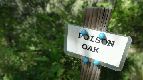
The next few days were not very fun. After passing mile 400, we moved into a burn area and encountered long stretches of trail that were overgrown with Poodle Dog Bush. Poodle Dog Bush seed lay dormant along the mountain sides until wildfires, after which they sprout. It is a known skin irritant like poison oak, and in this section of the trail, it is everywhere. There were numerous detours around it (including an 11-mile uphill road walk, which was loads of fun), but it was still hard to avoid. It was exhausting – hiking through Poodle Dog territory requires constant focus on the ground (carefully identifying the plants in front of you before taking each step), and it slowed us down quite a bit.

Finally, we made it to Agua Dulce and the Saufleys, who are probably the most legendary of all the PCT Trail Angels. They offer laundry, shelter, cots, showers, mail (both sending and receiving), hiker boxes, loaner clothes, kitchen, computers (what I’m on right now) and almost everything a hiker could want. Their backyard is filled with large tents with cots in them. Other Angels come from all over to help them with their operation, which is insanely efficient. We are taking a much-needed “Zero Day” here and will be back on the trail on Thursday. There is a long stretch of very hot desert in front of us to Tehachapi and then on to Kennedy Meadows and the start of the Sierra. We hope to night hike a lot of it to beat the heat!

image

The Wrightwood grocery store knows its audience

image

This is what a five-day resupply looks like for the two of us

image

373 miles down, 2,277 miles to go

image

A 1,500-year-old tree on the ridge of the San Gabriel Mountains

image

My Eagle Scout heart swelled with pride

image

On top of Mt. Baden Powell

image

Hiking the San Gabriel Mountain Range

image

Baby bear!

image

Baby bear number two!

image

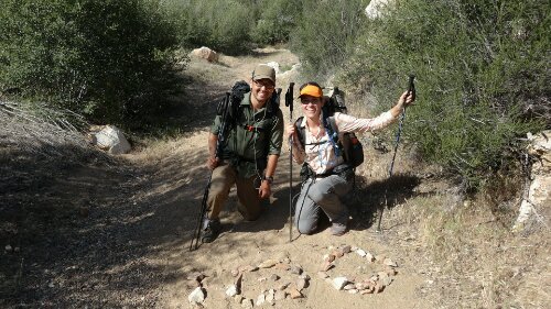
Mile 400! Our sign reads, “Shedder and Roo, we miss you! See you soon!” Shedder and Roo are two of our closest hiking buddies who sadly had to leave the trail last week due to a family emergency. They are meeting back up with us in Agua Dulce, and we can’t wait to have them back!!

image

Don’t forget the Poodle Dog Bush!!!!

image

Poodle Dog on the trail, in a section where it was relatively easy to avoid

image

Poodle Dog Bush

image

Along one of the Poodle Dog detours, we passed the area where, in 2009, a wildfire broke out, burning 251 sq. miles. It was later dubbed the “Station Fire” and took the lives of two fire fighters. This was the memorial to those brave men.

image

We explored the burned out US Forest Service Station, which was close to where the fire started. The fire was determined to be arson, but no one was indicated.

image

The cafeteria

image

Sad salt shaker

image

Oh, good.

image

The Saufleys base of operations

image

Tents at the Saufleys

image

The Saufleys

image

We ran into our old Husky friends

image

One of the many dogs at the Saufleys

image

Hiker packages at The Saufleys

image

Hikers love power outlets

image

Agua Dulce loves hikers! And we love Agua Dulce.

Day 24, Mile 369.5 – Hot Springs and Hot Days

Southern California’s climate has been much more diverse than we thought it would be. We always heard “the first 700 miles are in the desert.” Though we knew it wouldn’t be rolling sand dunes for miles off to the horizon (the stereotypical image the word “desert” often conjures), we also didn’t expect to encounter some of the coldest nights we’ve ever camped in (not to mention snow and hail on San Jacinto). From Campo to Big Bear Lake, we did encounter a few hot days, but they didn’t last long, and we were usually able to hike through them. But this last section of trail from Big Bear to Wrightwood gave us a little taste of what the dessert is really like.

Shortly after hiking out of Big Bear, we passed the 300-mile mark (yay!!), but things soon got difficult as we descended in elevation and the weather heated up. On our second day out of town, we walked for miles and miles along a shade-less ridge above Deep Creek – a gorgeous creek that wound through the canyon, always at least 50 feet below us, taunting us with its cool pools. Finally, after 20 LONG miles, we arrived at Deep Creek Hot Springs (apparently reputed to be one of the finest hot springs in the world, and it happens to be directly on the trail!), and we immediately jumped in the creek to cool off. Later we would tour the many small hot springs pools that lined the creek. It felt amazing – like a hot tub, warming our sore muscles.

The next day, we made it only six miles before we had to sit down and rest under a lone cedar tree with a group of other hikers. We stayed for four hours, waiting out the oppressively hot sun. My watch told me it was 95 degrees in the shade. It was extremely hard to leave that tree.

Hiking on, we met Interstate 15 and a sign pointing us to a McDonald’s. Now, we’ve heard about this particular McDonald’s for some time now – it’s kind of a hiker tradition. It comes within half a mile of the trail, and most hikers are drawn in by air conditioning and Big Macs. We were no exception. We were dreaming of ice and the burst of cold air when you open the doors. Even though it’s been probably 10 years since either Ashleigh or myself has been to a McDonald’s, we couldn’t help but be drawn in.

Hiking on from Interstate 15, we embarked on the longest (not necessarily the most difficult, but the longest) uninterrupted climb on the trail (20 miles of UP!) to the small ski town of Wrightwood, CA. After hitching a ride to town with some generous mountain bikers, we stayed with an amazing Trail Angel named Jeff – a 5th Grade school teacher who has no personal connection to the trail but began hosting hikers several years ago after noticing them in town. We are treating ourselves to a true “Zero” here in town and will head onward on Friday.

We’ve now completed just over 50 percent of the desert! Though it’s been tough, and hot, we are doing our best to embrace it as part of the trail experience. Tomorrow, we head out for an 85-mile section that will bring us to Agua Dulce.

image

Our ride to the trailhead out of Big Bear – an off-road Search and Rescue vehicle!

image

300 miles!!!

image

These two huskies are thru hiking with a couple from Seattle!

image

Enjoying Deep Creek Hot Springs with a beer we had carried 10 miles from Deep Creek Bridge (where some local Trail Angels surprised us with cold beer and snacks!)

image

The tree we sat under for four hours. As the shadow shifted around the tree throughout the afternoon, so did the hikers.

image

The desert is prettier than you think

This McDonald’s is so legendary among hikers, it is included on some maps

image

It’s also marked by a sign on the trail!

image

Big Macs! Tasted like high school.

image

Beginning the climb away from Interstate 15, we came upon striking views of Swarthout Canyon and the San Andreas fault. We camped on the fault line that night… and didn’t get swallowed into the earth!

image

A tarantula hawk (a type of spider wasp) dragging a tarantula along the trail. The hawk (we learned) had paralyzed the spider and will lay an egg on it, which will eventually hatch and eat its way out of the tarantula… WHOA, nature!!!

image

The “Chromie Homies” – our hiking buddy “Fun Size” and us, all toting Chrome Dome umbrellas from GoLite as we made our way toward Wrightwood

image

Hiking down to Wrightwood

image

Fun Size playing on the ski lifts above Wrightwood

image

Late night chit chat at Trail Angel Jeff’s wonderful home

Day 19, Mile 275.0 – Big Bear Lake and Slack-Packing

We’re officially past the 10% mark!! Hiking quickly over Mt. San Jacinto from Idyllwild, we out ran a storm on Fuller Ridge where it briefly snowed (!) on us. Hikers behind us were caught in the storm and told stories of extreme wind and ice.

It took us five days to get to the ski town of Big Bear Lake from Idyllwild. At mile 252, we caught a hitch into Big Bear from Jan and Roger, an amazing couple who had three Great Danes with them (Hi Ginger!). Though we’ve hitch hiked several times already (sorry, Mom – it’s pretty much a mandatory aspect of thru hiking), Jan and Roger provided the best ride by far! They generously drove PAST their own home to shuttle us into Big Bear City, waited patiently while we collected our resupply box from the post office, and then gave us a tour of Big Bear Lake before dropping us off at our hostel! Despite hitch hiking’s bad rep, the folks who have picked us up have been the kindest, most generous people ever, and we are SO grateful for their support. THANK YOU, Jan and Roger!!!

We stayed in a hostel on Thursday night, and the next day, Papa Smurf and Mountain Mama (local trail angels) gave us a lift back to mile 252. We “slack-packed” 23 miles to mile 275, where we caught a ride back to the hostel. Slack-packing is when hikers carry day packs (only what they need for the day – usually just food and water), so instead of a 30 lb. pack you carry a 5 lb. pack. It’s amazing. You feel like you can run the trail.

Today we head out toward the town of Wrightwood!!

image

Hiking through a rare patch of snow on the trail in the San Jacinto Wilderness

Uh oh.

Hiking on Fuller Ridge

image

Celebrating 200 miles!!!

image

Trail magic was waiting for us under Interstate 10.

image

Keepin’ it classy under the interstate

image

We arrived at Trail Angels Ziggy and the Bear, and they immediately sat us down for an epsom salt foot bath. Amazing!

image

We spent the night and much of the next day relaxing in Ziggy and the Bear’s backyard with a couple dozen hikers.

image

Mesa Wind Farm

image

Ashe, with Shedder and Roo, hiking out from Ziggy and the Bear’s

image

Family dinner at Whitewater Preserve, an old trout farm where we camped for the night. Clockwise from left: Frosty, Fun Size, Prophet, Shedder, Roo, Cuddles, Jess, and Robin Hood.

image

Early morning desert views

image

Morning break at one of the biggest creeks we’ve seen in awhile!

image

Another day, another national forest

image

Don’t step on the plants!

Day 12, Mile 179.4 – Celebrating 100 Miles

A few days ago, we reached the 100-mile mark (wooooo!!!!!!) and have now come nearly 200 miles through the heat of the Southern California desert. It has been surprisingly beautiful country – not what you think of when someone says “desert.” But it has been extremely hot during the day (95+ degrees) and cold at night (in the 30s). We’ve had some hard days and some long 20-mile stretches without water sources on the trail. Climbing into the San Jancinto Wilderness was especially difficult (but stunningly beautiful), as we reached 8,000 feet altitude with steep climbs and descents along cliffs with 100+ foot drops.

On Day 12, we made it to mile 179.4 and the wonderful mountain town of Idyllwild and are taking a much needed “Zero Day” here (a day when you don’t hike at all). Thank you SO much to Reina, who opened her beautiful home to us dirty hikers for a bed and a shower. On Sunday, we’ll hike on toward Big Bear City.

The 100-mile mark!!!

image

Dusk in the desert

image

Plodding…

image

Grady (one of our hiking buddies) on Eagle Rock…being an eagle.

image

Some of the exotic wildlife on the trail

image

Trail Angel Mike gave us water… and breakfast burritos!!!

If only all of the trail’s perils were so neatly labeled…

image

Water caches along the trail can be literal life savers

image

Some of the views

image

It can take a lot out of you to get over a tree in the middle of the trail. Especially after climbing 2,000 feet in the heat…

image

Desert mountain views

image

Hazel, the resident cat at Reina’s house in Idyllwild!

Day 5, Mile 77.3 – The Beginning

We made it!! Well…we made it to the Beginning.

We were picked up at the airport in San Diego by a Trail Angel named “Frodo” (of “Scout and Frodo”) on the 21st. Trail Angels are amazingly generous people who donate their time/money/food/homes/cars/etc. to support thru hikers. There’s an incredible community of them scattered all along the trail, and for many Angels, helping hikers becomes a full-time job this time of year.

Scout and Frodo are legendary Trail Angels. They operate a well-oiled machine and provided a warmer welcome to the PCT than we ever could have hoped for. They pick hikers up at the airport/train station/bus station, provide computer/internet access, printouts of the PCT water report, fuel for your cookstove (since you can’t bring it on the plane), shipping materials for hikers who need to work on their resupply boxes, breakfast, dinner, and snacks, showers, beds/camping space, a ride to the trailhead, and more. This year, several HUNDRED hikers will come through Scout and Frodo’s – probably a quarter of all 2013 thru hikers, if not more. They. Are. Amazing.

We stayed at Scout and Frodo’s for one night with about 15 other hikers, and they drove us to the Southern Terminus of the PCT the next morning at 6am.

The home of our Trail Angels Scout and Frodo

image

They made amazing food for all the hikers!

We even enjoyed a cello concert by a hiker named Mark (aka “Cuddles”) – a professional cellist, who is thru hiking the PCT this year and playing shows in trail towns along the way

The monument at the Southern Terminus of the PCT

Obligatory photo

Touching the Mexican Border

We were planning to take it easy the first couple weeks – less than 12 mile days. But the severe shortage of water in southern California (this is a particularly dry year) has made it difficult. The first 20 miles of the PCT were waterless. So we decided to hike all 20 miles in one day, carrying 5 liters of water each.

Only 2,659 miles to go!

An umbrella helps keep the sun off and has quickly become our favorite piece of gear

The days are hot and the nights are cold out here. We try and get up by 5am and get most miles done in the morning and evening.

There was a freak storm on Thursday and we had to get all bundled up, rain coats and all. A couple hours later, it was horribly hot.

As of Day 5, we’ve made it 77.3 miles to a town called Julian and are currently about 35 miles ahead of schedule. We will spend a night here to rest (and shower!) before hiking on.

Mom’s Pie shop in Julian offers a free slice of pie with ice cream to all thru hikers

Mmmmmm….. pie

“Hiker Trash” – the common term for a group of loitering hikers